It is for doing mapping so I can get better, so thank you guys! Google Maps is my main option but I am in Rank 149 of OpenStreetMap! Thank you for @DavidDean as he said he was in the top 50 in 2008! I specifically like you guys! Kind Regards, Brilloant
Users' Diaries
Recent diary entries
2024年4月3號花蓮外海發生規範 7.2 強烈地動,造成嚴重 ê 道路中斷 kah 人命傷亡。OpenStreetMap Taiwan 社群開設下跤三个專案,向望各界鍵盤圖客支援繪製花蓮 ê 建築、土地利用 kah 落勾 ê 道路 kah 溪流:
- 中橫公路東段:https://tasks.hotosm.org/projects/16508
- 蘇花公路:https://tasks.hotosm.org/projects/16507/
- 花東縱谷北段新城、秀林、花蓮、吉安、壽豐:https://tasks.hotosm.org/projects/16505
這馬佇咧參詳地動了後 ê 衛星影像捐贈 ē-tàng iōng tī 繪製新 ê 地貌,並且 tī 主要災後復原了後,期待直接 tī 在庄 ê 實體活動,幫助在庄 ê 人。
On April 3, 2024, an earthquake happened outside the coast of Hualien, which caused serious roadblocks and human casualties. OpenStreetMap Taiwan has opened 3 projects for mapping affected areas, requesting worldwide mappers to map buildings, landuses, missing roads or waterways in Hualien.
- Central Cross-island Highway eastern section: https://tasks.hotosm.org/projects/16508
- Suhua Highway: https://tasks.hotosm.org/projects/16507/
- Hua-Dong Valley northern part, Sincheng, Siulin, Hualien, Ji’an, Shoufong: https://tasks.hotosm.org/projects/16505
We are talking if there is a possibility to donate the newest satellite image after the earthquake to map the after-earthquake situations. And the possibility of hosting mapping events on-site after the affected area returns to normal, helping locals by mapping the newest map data.
Zawsze można spotkać się
2024年4月3日花蓮外海發生規範7.2強烈地震,造成嚴重的道路中斷與人命傷亡。OpenStreetMap Taiwan 社群開設以下三個專案,企盼各地鍵盤圖客支援繪製花蓮的建築、土地利用與遺漏的道路與溪流:
- 中橫公路東段:https://tasks.hotosm.org/projects/16508
- 蘇花公路:https://tasks.hotosm.org/projects/16507/
- 花東縱谷北段新城、秀林、花蓮、吉安、壽豐:https://tasks.hotosm.org/projects/16505
目前在洽談震災後的衛星影像捐贈用來繪製新的地貌,並且在主要災後之後,期待直接在當地的實體活動,幫助在地民眾。

That’s the name of the workshops I facilitated last week, with the goal of introducing/promoting OpenStreetMap, along with introducing tools like FieldPaper, OpenAerialMap, Sketch-Map Tool and Umap, to meet the objectives of local DRR practitioners’ upcoming mapping initiative.
Last Friday I had conducted two workshop in Iloilo, one (unplanned) for Iloilo’s Provincial DRRMO (disaster agency), and another for Iloilo City own DRRMO. In the Philippines, city charters may provide them autonomy from the geographic province they’re part of. These Disaster Risk Reduction Management Offices (a tongue-full, I know) are the government agencies responsible for mitigating localized disaster risks, and planning for disaster prevention for their respective territories.
Last year, in a random visit in Iloilo, I met some folks from the City DRRMO team and since then, I found out that they’ve capturing community-based hazard risks and perceptions using FieldPapers. Unfortunately, FieldPapers uptime wasn’t as reliable as before, and eventually the built-in Bing imagery became unavailable, too.
I’ve kept in touch with the City’s DRRMO team, and when I told them of a planned (gustatory) visit, they asked if I could run another training workshop for them. The small workshop was planned for a dozen people, but the day before the workshop I was surprised to learn than they confirmed 28 participants, and couldn’t even accommodate my own guests.
Well, that’s how I ended up with two separate workshops, discussing the same topic, but interestingly, the engagement was different with one group being more technical, and familiar with geodata/GIS/maps, and the other are more focused on being able to collect local spatial knowledge.
Anyway, with the feedback about issues they’ve been encountering with FieldPapers, I ran into the updated Sketch-Map Tool which now has built-in ESRI Aerial Imagery included.
FieldPapers (FP)
One of the earliest Pen & Paper tools I’ve learned to like, especially when working with folks averse to “tech”. It’s cheap, and it (used to be quite) reliable.
Creating maps could be tedious, manually requiring people to manually define their area of interest. I think it’s been years since the search function last worked properly.
The participant’s favorite feature is FP’s ability to use external TMS endpoints, and in our case, I demonstrated how OpenAerialMap imagery taken from drones can be used to deploy fresh maps that can be used as background of maps they wish to deploy on the ground.
They participants also like how FP serves TMS tiles of the uploaded snapshot (marked-up) map, which they can use as a background layer on iD (or another editor) for digitizing on OpenStreetMap.
Maximum paper size is ISO A3, which isn’t probably big enough when you expect participants to work together as large groups. That size is more than sufficient for individual mappers though.
If the users aren’t conscious about it, they may inadvertently create atlases with snapshots that may reveal personal or private information, so that’s one thing users should really watch out for.
Sketch-Map Tool (SMT)
This recently revamped tool now comes with built-in satellite imagery from ESRI, but you’re limited to that or the Mapnik (OpenStreetMap’s default layer) background for your maps.
The interface for creating maps is more friendly, and the OHSOME map quality report helpful, but it becomes tedious when you need to create separate maps for a large area, which one has to to create one-by-one.
One of the favorite features for SMT is it’s built-in ability to digitize (properly) marked features and create GeoTIFF and GeoJSON files out of the marked-up map. The data is not stored in HEIGIT's servers, so the risk of accidental disclosure of private information is minimized. Update: 2024-04-22 According to mschaub’s comment, the data is actually stored in HeiGIT’s server, but becomes inaccessible after a day:
One small correction I would like to make (or maybe I misunderstood you): We do store the original sketch map and the uploaded sketch map with markings on them on our servers. The first one, we need to be able to do georeferencing of the sketch map after it was uploaded. The second one we store to be able to improve our machine learning models which are responsible for detecting the markings. We do point this out to the users (see text on the upload dialog). But it is not possible, even with the right URL, to download any of those files one day after they were created. So data is stored on our server, but the risk of accidental disclosure of private information is also minimized.
During the role-playing segment, we experienced how quick the process may be like, from map creation, to the mark-up/reporting process, and the automatic digitization, then visualizing the created GeoJSON files quickly, using Umap.
Over-all, everyone found the tools easy-enough to learn, and accessible for their capacity level.
At it is, these two tools are complementary and one could be more useful than the other, depending on the users’ priorities. To wit:
| FieldPapers | Sketch-Map Tool | |
|---|---|---|
| supported layer | Mapnik, HOTOSM, TMS | Mapnik, ESRI Imagery |
| interface | functional, but search doesn’t work | more user-friendly, works as expected |
| registration | optional | none |
| max. paper size | ISO A3 | ISO A1 |
| geodata | GeoTIFF | GeoTIFF, GeoJSON |
| TMS of marked-up map | yes | no |
| multi-map support | yes | tedious |
| privacy risks | moderate | low |
I’m excited by the initiatives being drawn-up by both DRRMOs, though they are still working independent of each other.
The search and rescue team, and the local fire department, were very enthusiastic about using Pen & Paper to help map location of water wells (parts of the city are experiencing drought), while the search and rescue intends to use them for mapping highways attributes (width and access) and missing footways and paths, to improve response times during emergencies.
I see a potential to make more use of OpenStreetMap data in their local communities, encouraging local contributors to keep the map updated and relevant for their own needs, and the participatory approach they are undertaking, in collecting local spatial knowledge and experience, which could lead to improved usability of gained results for local capacity assessments, and the role of the OSM ecosystem of data and tools serving as a bridge into their formal DRR process.
I would’ve loved to see more of the local active mappers participating in the event and planned activities, but unfortunately, we failed to receive any word from the folks we reached out to.
Gallery
Below is a collage of some photos from the activity.
While commercial map providers like Google, provide map data in local Indian languages, the local language labels are usually transliterated from English, resulting in errors. OSM, Wikidata and Wikipedia platforms provide a way to improve the local language maps leveraging multilingual labels through Wikidata identifiers on OSM, through semi automated updates. For good quality maps on Wikipedia and OSM, the Wikidata location needs to be accurate and Wikidata identifier should be uniquely mapped to the actual OSM geometry. I worked on removing the mismatches for villages of a district in Andhra Pradesh. I have documented my experience as clearly as possible, so that even users with less programming and tools skills can contribute to the work. As an example, identifying and fixing errors in Wikidata location is given below.
Identifying and fixing error in locations on Wikidata pages
 The geodata is presented in Wikidata page and corresponding English Wikipedia article page using OSM as background map. If one notices that the marker is not near to the names identified on OSM map, then there is possibility of an error. Even if the name is identified on OSM background map, selecting different zoom levels allows checking whether the place is in the correct location.
 The correct geolocation is obtained from Open Data compliant StateGIS portal run by Bharatmaps.
 After Wikidata coordinate location is updated with the correct data, Wikidata page and the corresponding English wiki article show the correct map.
Full article covers how to identify more complex errors based on the geographical distance between Wikidata location and OSM node location and also when the Wikidata and OSM geometry that is associated are outside the area of interest. Sample Wikidata Sparql scripts leveraging Sophox interface to OSM, which can be easily edited are provided to help contributors with less programming and tool skills to contribute to these efforts.
For more information, check out Improving geodata accuracy on OSM and Wikidata (Full article on OSM wiki) and let me know your feedback.

![]() As we announced in a previous post, we continue to inform the OpenStreetMap LATAM community about the SOTM LATAM 2024 committees, and now we present the Programming Committee.
As we announced in a previous post, we continue to inform the OpenStreetMap LATAM community about the SOTM LATAM 2024 committees, and now we present the Programming Committee.
The main functions of this committee are:
- Propose the activity program during the days of the SOTM
- Design protocol activities
- Design the event Tracks
- Design parallel activities
- Design recreation activities
- Coordinate with the speakers what is necessary for their participations
- Evaluate the carrying out of recognition of mappers in the region
The committee members are:
| Member | Representation | Position | Role |
|---|---|---|---|
| Anderson Toniazo | OSM Brasil | Member | Organizing Committee |
| Virginia Brussa | OSM Argentina | Member | |
| Olga Paredes | OSM Bolivia | Member | |
| Yasmila Herrera | Yeka Street | Member | |
| Sebastián Bravo | Youthmappers SAGEMA | Member | |
| Mariela Centeno | Youthmappers ESPE | Member | |
| Juan A. Barajas | Youthmappers LATAM | Member | Organizing Committee |
This committee should have its first meeting in the coming days to elect its president and begin carrying out its duties.
Posted by Cyberjuan on 9 April 2024 in Spanish (Español).
Last updated on 10 April 2024.
![]() Tal como anunciamos en anterior post, seguimos informando a la comunidad OpenStreetMap LATAM sobre los comités del SOTM LATAM 2024, ahora les presentamos al Comité de Programación.
Tal como anunciamos en anterior post, seguimos informando a la comunidad OpenStreetMap LATAM sobre los comités del SOTM LATAM 2024, ahora les presentamos al Comité de Programación.
Este comité tiene como principales funciones:
- Proponer la programación de actividades durante los días del SOTM
- Diseñar las Actividades protocolares
- Diseñar los Tracks del evento
- Diseñar las Actividades paralelas
- Diseñar las Actividades de recreación
- Coordinar con los ponentes lo necesario para sus participaciones
- Evaluar la realización de reconocimientos a los mapeadores de la región
Los miembros del comité son:
| Miembro | Representación | Cargo | Rol |
|---|---|---|---|
| Anderson Toniazo | OSM Brasil | Miembro | Comité de Organización |
| Virginia Brussa | OSM Argentina | Miembro | |
| Olga Paredes | OSM Bolivia | Miembro | |
| Yasmila Herrera | Yeka Street | Miembro | |
| Sebastián Bravo | Youthmappers SAGEMA | Miembro | |
| Mariela Centeno | Youthmappers ESPE | Miembro | |
| Juan A. Barajas | Youthmappers LATAM | Miembro | Comité de Organización |
Este comité debe tener su primera reunión en los próximos días para elegir a su presidente y empezar a cumplir sus funciones.
Si usted cree que puede aportar a este comité favor de comunicarse al correo state arroba osmlatam punto org.
Well did that alone
![]() As we announced in the previous post, we continue to inform the OpenStreetMap LATAM community about the SOTM LATAM 2024 committees, and now we present the Academic Program Committee.
As we announced in the previous post, we continue to inform the OpenStreetMap LATAM community about the SOTM LATAM 2024 committees, and now we present the Academic Program Committee.
The main functions of this committee are:
- Evaluate the presentation proposals received
- Evaluate scholarship applications received
- Management of travel and accommodation scholarships
As additional information for those interested in presenting a talk or presentation, the topics may be (but are not limited to):
- Mapping projects developed or under development in the region.
- Projects to improve the labeling system in the region.
- Projects to improve the use of notes in the region.
- Extrinsic or intrinsic quality assessment of OpenStreetMap data
- Analysis of contribution patterns in OpenStreetMap
- Generation of new and scientifically valuable datasets from OpenStreetMap
- Assessments of data import procedures and their impacts on data and community
- Integration between OpenStreetMap and other data sources (authoritative, user-generated, or otherwise valuable to OpenStreetMap)
- Analysis/comparison of available software for scientific purposes related to OpenStreetMap
- Novel approaches to facilitate or improve data collection and/or data quality in OpenStreetMap (e.g. through gamification or citizen science approaches)
- Artificial Intelligence / Machine Learning from, and with OpenStreetMap (e.g. AI-assisted mapping)
- Open research problems in OpenStreetMap and challenges for the scientific community
- Cultural, political, and organizational aspects of data production and usage practices in OpenStreetMap
- Studies using OpenStreetMap data in scientific domains
- Reviews of any scientific aspect connected to OpenStreetMap
The committee members are:
| Member | Representation | Position | Role |
|---|---|---|---|
| Rodrigo Smarzaro | UMBRAOSM | Member | Organizing committee |
| Matheus Correia | COIMBRA Univ. | Member | |
| Nathan Damas | Youthmappers UFPR | Member | |
| Kauê de Moraes V. | Youthmappers UFPR | Member | |
| Maya Lovo | Youthmappers | Member | |
| Carolina Garcia | Youthmappers ESPE | Member | |
| Patricia Llanos | SBCS | Member | |
| Sandra Hernandez | Youthmappers Uaemex | Member |
This committee should have its first meeting in the coming days to elect its president and begin carrying out its duties.
Posted by Cyberjuan on 9 April 2024 in Spanish (Español).
Last updated on 10 April 2024.
![]() Tal como anunciamos en el anterior post, seguimos informando a la comunidad OpenStreetMap LATAM sobre los comités del SOTM LATAM 2024, ahora les presentamos al Comité de Programa Académico.
Tal como anunciamos en el anterior post, seguimos informando a la comunidad OpenStreetMap LATAM sobre los comités del SOTM LATAM 2024, ahora les presentamos al Comité de Programa Académico.
Este comité tiene como principales funciones:
- Evaluar las propuestas de ponencias recibidas
- Evaluar las solicitudes de becas recibidas
- Gestión de becas de viajes y alojamiento.
Como información adicional para quienes estén interesados en presentar una charla o ponencia, los temas de estas pueden ser (pero no están limitadas a):
- Proyectos de mapeo desarrollados o en desarrollo en la región.
- Proyectos para mejorar el sistema de etiquetado en la región.
- Proyectos para mejorar el uso de las notas en la región.
- Evaluación de la calidad de los datos de OpenStreetMap
- Análisis de patrones de contribución en OpenStreetMap
- Generación de conjuntos de datos nuevos y científicamente valiosos a partir de OpenStreetMap
- Evaluaciones de los procedimientos de importación de datos y sus impactos en los datos y la comunidad.
- Integración entre OpenStreetMap y otras fuentes de datos (autorizadas, generadas por el usuario o de otro modo valiosas para OpenStreetMap)
- Análisis/comparación de software disponible con fines científicos relacionados con OpenStreetMap
- Enfoques novedosos para facilitar o mejorar la recopilación de datos y/o la calidad de los datos en OpenStreetMap (por ejemplo, a través de enfoques de gamificación o ciencia ciudadana)
- Inteligencia artificial/aprendizaje automático a partir de y con OpenStreetMap (por ejemplo, mapeo asistido por IA)
- Problemas abiertos de investigación en OpenStreetMap y desafíos para la comunidad científica
- Aspectos culturales, políticos y organizativos de las prácticas de producción y uso de datos en OpenStreetMap
- Estudios que utilizan datos de OpenStreetMap en dominios científicos
- Reseñas de cualquier aspecto científico relacionado con OpenStreetMap.
Los miembros del comité son:
| Miembro | Representación | Cargo | Rol |
|---|---|---|---|
| Rodrigo Smarzaro | UMBRAOSM | Miembro | Organizing committee |
| Matheus Correia | Univ. COIMBRA | Miembro | |
| Nathan Damas | Youthmappers UFPR | Miembro | |
| Kauê de Moraes V. | Youthmappers UFPR | Miembro | |
| Maya Lovo | Youthmappers | Miembro | |
| Carolina Garcia | Youthmappers ESPE | Miembro | |
| Patricia Llanos | SBCS | Miembro | |
| Sandra Hernandez | Youthmappers Uaemex | Miembro |
Este comité debe tener su primera reunión en los próximos días para elegir a su presidente y empezar a cumplir sus funciones.
Si usted cree que puede aportar a este comité favor de comunicarse al correo state arroba osmlatam punto org.

So I thought surveys meant that I go out and ask people… conduct a survey, but apparently it means that you have been there personally to check it… so… that means I didn’t tag any of my entries where it would apply with this… lol

Welcome to my fourth OpenStreetMap NextGen development diary.
Sorry for being a day late! I wanted to finish up one of the new features which caused this small delay. ✨
🔖 You can read my other development diaries here:
https://www.openstreetmap.org/user/NorthCrab/diary/
🐙 My work is available publicly on this GitHub repository:
https://github.com/Zaczero/openstreetmap-ng
Let’s summarize the last week’s work:
Client-side Trace Images
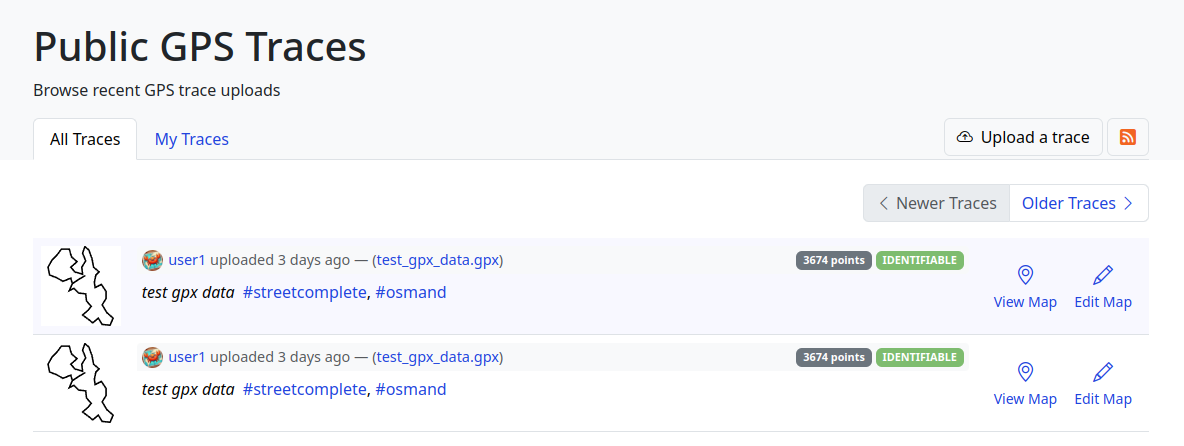
While migrating the traces functionality, I came up with an amazing and seemingly obvious idea. Why not make trace images SVGs and render them client-sided? This feature has few significant advantages: even faster trace uploading, no additional disk usage, unlimited customization, infinite resolution, faster page loading. And so here it is:
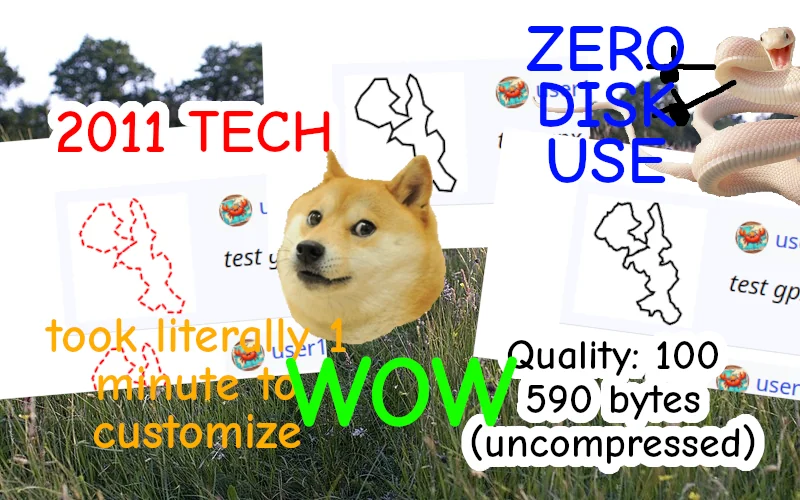
The application can freely adjust the quality of generated images. The code can also be reused for implementing proper trace-on-map rendering, which is one of the new upcoming features.
SVG supports animations too!

Refreshed Traces UI
Last week I have also worked on refreshing the traces UI, focusing on making it more open and friendly. If you have been following my previous diaries, you may recognize some of the new style language.
Deployment Scripts
I also wrote and successfully tested server-deployment scripts for the application. They are currently a part of the openaedmap-backend project but will soon be copied over to the openstreetmap-ng. Both projects share many similarities in how they are run.
Final Words
Previous development diary #3 was packed with lots of new stuff. I took this week a little slower to catch a breath. Meantime, I contributed to other projects (openaedmap, starlette) and also helped OSM-PL with server migration process. I was also away for a short time for some BBQ🌞!
Project Sponsors 🏅
Thank you to this week’s project patrons! I truly appreciate your every contribution!
Currently, the project is sponsored by 11 people!
Five private and three public donors on Liberapay, and three public on GitHub Sponsors.
If you can, please consider supporting the NG development. Any amount helps me focus on making high-quality free software for everyone to enjoy! (shh… next week I will announce a new supporter benefit) 😋

Disclaimer
This project is not affiliated with the OpenStreetMap Foundation.
Not A Goodbye!

This is the Closing Chapter! However, the story continues😀
My friend (and colleague) Ola messaged me and asked, “Eden, how do you feel, that your internship at HOTOSM is ending soon?” I took a long pause to answer that 🥹.
As the curtains draw close on this chapter of my professional journey, I find myself reflecting on colourful experiences, lessons, and memories that have defined my time as an intern at HOTOSM.
It’s been 3 months already!?🥹 Like someone rightly said “time goes by quickly, when you are having fun”. I’m usually the type of person that looks forward to the end of a thing because I learnt to always finish what I started. But this time, it felt weird! A mix of nostalgia and anticipation.
I love it at HOT and I will forever cherish my time here; where every encounter was a lesson and every challenge a stepping stone. The vision, the community, the staff, the enriching days of inspiring coffee chats, talks with my favourite colleague, the opportunities, the work I did, and my wonderful mentor, Petya Kangalova.
Throughout these past 3 months, I’ve been privileged to be guided by the most amazing mentor ever, Petya Kangalova, who generously shared wisdom, resources, expertise, and opportunities for me to grow. Each day presented a fresh “GO!” for me to experiment, iterate and grow. From navigating the complexities of projects to engaging in insightful conversations on Mondays (and other days). Every moment has contributed to my development as a professional and my confidence as an individual.
What’s next?
I’m proud of myself for the work I did, and the initiatives I took in an attempt to maximise my time with HOT. I got really sweet feedback that will forever keep me motivated. And the story continues, it doesn’t end now. Not anytime soon. I am thankful for the opportunity to be a co-mentor for the next round of Outreachy internship at HOTOSM.
Part of what’s next for me is to continue contributing to HOT’s open source project, with a special interest in HOT’s fAIr software. fAIr is an open AI-assisted mapping service software, that aims to improve the efficiency and accuracy of mapping efforts for humanitarian purposes.
If you’re a beginner to open source and don’t know where to start, but excited to do so, I recommend joining the HOT Tech and Innovation Working Group to learn and grow your skill, within an inclusive community. And If you want to get your hands busy right away, check for “good first issues” or “beginner friendly issues” at the HOT Github page.
You can also watch this comprehensive video guide on how to contribute to HOTOSM open source projects on Github. Listen to our active contributors share their experience contributing to HOT’s open source project.
C’est fini – but it is also a new beginning. With a heart of gratitude and determination, I step forward, eager to embrace the next challenge, and open to the endless possibilities that await beyond the threshold of familiarity.
Special thank you to my mentor, Petya Kangalova. Thank you HOTOSM, Outreachy internship – you have been more than a chapter; you have been a transformational point in my professional journey, guiding me towards the horizon of endless possibilities.
If this is your first time reading my diary, please catch up with my previous blogs here or connect with me and reach out via X @edenxcodes to stay updated on my next steps.
Till next time,
Eden.
Posted by Juan Agustín Flores on 7 April 2024 in Spanish (Español).
Primer entrada
Nada por ahora esto es solo una muestra
[Deleted]
[Deleted]
Posted by Rukkhadevata on 7 April 2024 in Chinese (中文).
Last updated on 15 April 2024.

The situations described in this article are limited to Mainland China. The administrative divisions in Mainland China are very complex, and even for natives, it is difficult to understand them all at once. Therefore, please make sure you have a thorough understanding of the administrative divisions in Mainland China before editing relevant content.
| 参考:OSM Wiki | China/Boundaries & Zh-hans:中华人民共和国#中国行政区划 |
(本文有若干内容是在发表后逐渐加入,若发现错漏或有任何疑问,恳请评论或发站内信指出)
本文旨在厘清中国大陆高度复杂的行政区划体系,并为希望完善相关数据的 OSM 贡献者们提供指引。本文所述内容及标注规范仅限于中国大陆地区(港澳台地区的情况请咨询相应社区),包含:
- 法定行政区;
- 非法定行政区;及
- 标签的值与位置。
1 法定行政区
《中华人民共和国宪法》中有如下规定:
第三十条 中华人民共和国的行政区域划分如下:
(一)全国分为省、自治区、直辖市;
(二)省、自治区分为自治州、县、自治县、市;
(三)县、自治县分为乡、民族乡、镇。
直辖市和较大的市分为区、县。自治州分为县、自治县、市。
自治区、自治州、自治县都是民族自治地方。
1.1 含义
理论上来说,中国大陆的行政区划体系应该与如上规定一致。然而,几乎任何在中国大陆生活过的人都会立刻发现,这其中缺少了一个非常重要的概念:地级市。实际上,在法律法规资料库中,你几乎不可能找到「地级市」这个概念,在不得不提及时也会使用「设区市」或近义词。这是因为在实务中,地级市可能还管辖着县级市,而市不能下辖市,因此绝大多数县级市的名义都是「xx省直辖,xx市代管」(注1),不过通常可以将其视为仅由地级市管辖(但独立性相比县为强)。
此外,特区和林区(各自均仅有一例)作为历史遗留,也被承认为正式的县级行政区;部分民族自治区域也未写入法条。
因此,中国大陆的法定行政区如下表所示(注2):
| 行政区等级 | 行政区类型 |
|---|---|
| 省级 | 省、自治区、直辖市 |
| 地级 | 地级市、地区、盟、自治州 |
| 县级 | 县、自治县、县级市、旗、自治旗、市辖区、特区、林区 |
| 乡级 | 乡、民族乡、苏木、民族苏木、镇、街道 |
| 村级 | (行政)村、牧委会、嘎查、社区 |
注1:部分县或县级市为「省直辖县级行政单位」,其不受地级单位管辖,行政区划代码第 3、4 位为特殊的 90,如湖北省仙桃市、河南省济源市、海南省临高县等。「省直辖县级行政单位」与「直筒子市」的区别在于名义上前者缺少地市一级,后者缺少区县一级
注2:根据《中华人民共和国民族区域自治法》第二条、第十二条,民族区(例)、民族镇(例)并非民族自治地方,目前一般将后两者视同普通区和镇。
1.2 标注等级
在关系 (relation) 中使用 admin_level,而在节点 (node) 上使用 capital。比如,一个县的关系中应有 admin_level=6,而该县的节点(place=city)上应有 capital=6。以下是各级行政区的标注等级:
| 行政区等级 | admin_level/capital |
|---|---|
| 省、自治区、直辖市 | 4 |
| 地级市、地区、盟、自治州 | 5 |
| 县、自治县、县级市、旗、自治旗、市辖区、特区、林区 | 6 |
| 乡、民族乡、苏木、民族苏木、镇、街道 | 8 |
| (行政)村、牧委会、嘎查、社区 | 10 |
2 非法定行政区(「黑区」)
看起来,这套行政区划体系似乎非常清晰。然而理想是美好的,实际上,以下情况都存在:
-
每一级行政区都存在实际管辖范围与其法定管辖范围不同的情况;
-
某些行政区并不归其法定的上级管辖,而是由(通常是更上一级的)一个派出机构——通常是管委会——管辖,这些管委会的职能无限接近于一级政府,然而民政部并不承认它们是正式区划;
-
上一条所述的管委会与一个法定行政区合署办公(一个机构两块牌子,实际上是管委会取代了地方政府),但管委会的管辖范围大于挂名的法定行政区。
举例来说,上面三种情况分别有:
-
西藏自治区实际管辖着分属青海省海西蒙古族藏族自治州和玉树藏族自治州的大片土地,并设置有法定的乡镇级区划(你可能已经发现 OSM 上的青藏省界不太寻常);
-
武汉经济技术开发区(汉南区)是一个机构两块牌子,但前者的管辖范围还包括蔡甸区和汉阳区的部分区域,这两个区也在规划文件中间接承认经开区对其的管理。
如果你居住在中国大陆,感受可能会更加明显:你有可能就生活在这种名义上属于法定区县,但实际上由管委会管辖的地方;这些非法定的行政管理区就是俗称的「黑区」。
2.1 含义
通常来说,如果一个地方由省、地、县级政府的派出机构管辖经济社会事务,该处就可以被称作一个「黑区」(包括但不限于国家级新区、经济技术开发区、高新技术产业开发区等未在民政部行政区划统计表中的行政区划)。为了便于管理,「黑区」的边界通常都由法定行政区的边界组成(但可能是镇街甚至村社的边界)。
「黑区」既可能管辖县、镇、街道、村,也可能自行设立与法定行政区不完全重合的下级管理区。对于前一种情况可以根据下表进行分类,后者则可以参考管委会行政级别确定。
| 「黑区」等级 | 下辖 |
|---|---|
| 准地级 | 县 |
| 准县级 | 镇、街道、乡等 |
| 准乡级 | 村、社区等 |
注意:由于 OSM 遵循「de facto」即实控原则,某些情况下黑区的存在会改变法定行政区的边界范围,使其与官方或商业地图不一致(有些标注模式甚至仅在 OSM 出现),如:
这些都属于正常现象,因此在发现县级边界与其它地图不同时请不要贸然修改,应在查证实际管理情况后再做操作。(需要指出的是,只有在法定行政区托管或实控其它区域的情况下法定行政区界才会变动,否则相应区域通常用 admin_level=7 的「黑区」加盖)
2.2 标注等级
与法定行政区一样,「黑区」的关系中仍然使用 admin_level,但并非所有的「黑区」都要有节点(主要取决于名称是否被当作地名使用或者管委会驻地是否位于独立于法定行政区的聚落,如类似「xx经济技术开发区」的单纯性质名称就不应有节点,另见注2)。
根据下辖区划的不同,笔者粗略地将黑区的标注分类如下:
| 「黑区」等级 | 下辖 | admin_level/capital | 举例 |
|---|---|---|---|
| 准地级 | 县 | 5 | 当前仅有雄安新区 |
| 准县级 | 镇、街道等 | 6 | 注1 |
| 准县级 | 镇、街道等 | 7 (注3) | 安徽省芜湖市芜湖经济开发区(340271) |
| 准乡级 | 村、社区等 | 8/9 (注4) | 江西省南昌市南昌县小蓝经济开发区(360121403) |
注1:当前仅包含加格达奇区、松岭区、新林区、呼中区、苏州工业园区、深汕特别合作区、大柴旦行政委员会
注2:仅下辖虚拟社区/生活区的「黑区」仅应有边界(若存在)关系而不应有label,如天津市宝坻区京津中关村科技城(120115457)下仅有虚拟社区(120115457498)
注3:在中国大陆,admin_level=7 不能单独存在,其范围必然与一个或数个法定行政区的范围重叠
注4:统计局口径下管辖村社的准乡级「黑区」可能难以找到属于哪一法定乡镇的管辖范围,同时它们还可能自行设立分管若干村社的管理区。因此该级别「黑区」的标注方式还未完全确定,在前者情况下可酌情使用 admin_level/capital=8
3 标签
3.1 标签的值
3.1.1 区域型标签
目前在中国大陆地区,place=state/region/county/district 一般用于区域型政区的替代渲染(大多是第三方服务,如 OsmAnd),比如 OSM Carto(也就是 OSM 网站的默认渲染)中看到的「xx省」字样就是由这类标签渲染出来的(而黑色字的「xx市」则由 place=city 渲染)。
具体而言,place=state 代表省级行政区(例),place=region 代表地级行政区(例),place=county/district 代表县级行政区(例)。
当前,对县级行政区的标注不统一且没有公认的规范(如,有些市辖区似乎没必要渲染区域型名字,同时 place 用 county/district 仍存在争议)。
3.1.2 通常的行政区标签
| 等级 | capital | place (注1) | 举例 |
|---|---|---|---|
| 省级行政中心 | 4 | city | 呼和浩特市 |
| 地级行政中心 | 5 | city | 黑河市 |
| 县级行政中心 | 6 | city | 大同区 |
| 乡镇驻地 | 8 | town/suburb (注2) | 松花江镇 |
| 村社驻地 | 10 | village/quarter (注2) | 小张各庄村 |
注1:大部分行政区节点标签应同时有 place:CN 标注
注2:属于城市建成区一部分的街道和社区分别使用 place=suburb/quarter,但非位于更大聚落的或乡镇改制的街道,以及除街道和社区以外的任何乡镇级区划,仍一律标注 place=town/village
3.1.3 「黑区」的标签
(参照 §2.2 标注等级)
| 「黑区」等级 | capital | place | 举例 |
|---|---|---|---|
| 准地级 | 5 | city | 当前仅有雄安新区 |
| 准县级 | 6 | city | 注3 |
| 准县级 | 7 | city/town (注4) | 兰州新区 |
| 准乡级 | 8/9 | town |
注3:当前仅包含加格达奇区、松岭区、新林区、呼中区、苏州工业园区、深汕特别合作区、大柴旦行政委员会
注4:有必要标注节点的准县级「黑区」使用 place=city/town 存在争议
3.2 标签的位置
本节只讨论 place=city/town/village 等定居点的标签,不含区域型标签如 place=region/county。
中国大陆的商业地图通常将行政区名所在的节点标注在政府(或村委会等)所在地,然而这经常会导致该节点不具有指向作用,因为相当数量的市、区、县政府都并不位于城镇中心甚至城镇内(比如,仅辽宁一省就有沈阳、本溪、铁岭、丹东、盘锦五个地级市政府的位置不在主城区)。此外,由于许多镇被改制为街道或撤并入其它乡镇,表示它们的节点也消失在商业地图上。
因此,对于有标签的行政区,建议其标签位置遵循如下原则:
-
市辖区以外的县级行政区:公众认知的城镇中心标志物(如成都天府广场、长春人民广场、西安钟楼等)或建成区的大致中心位置(没有前者时);
-
市辖区:(若由县或县级市等改制而来则参照前一条)若该区域没有明显的中心,可放在区政府处,也可在区名所在的地标处(需要在区内,如武汉市洪山区就只能放在区政府处)。特别地,如果区政府在建成区外,节点就不可放在区政府处而只能移动到建成区内;
-
街道以外的乡级行政区:若乡镇政府在所驻集镇建成区则标在该处,否则参照第一条(后者情况较少,如滁州市来安县水口镇);
-
街道:(若从乡镇等改制而来则参照前一条)标注在街道办事处处(若其在辖区外则不标注节点),然而当前是否标注城区析置街道存在争议;
-
村级行政区:村部(或社区居委会等)处(当前对村级行政区的标注争议较大)。
特别地,抚顺县(辽宁省抚顺市)和沧县(河北省沧州市)没有县城,政府驻地位于其它区,因此没有 place=city 节点。此外,某些行政区的政府驻地在辖区外但有自己的城区,如安次区(河北省廊坊市),参照前文所述标注即可。
Overview
Progress has been solid over the past week. My main focus is still trying to add in as many missing buildings as possible, but I’ve covered the following during the week:
-
Micromapping. While fixing two schools and two shopping centres, I decided to micromap them using a combination of aerial imagery and my local knowledge.
-
More buildings. I’m still just trying to “fill in the blanks” and get buildings added.
-
Small fixes. While doing other mapping, I came across various small issues that I fixed at the same time.
Micromapping
Schools
While updating some details for Victoria Park High School & Victoria Park Primary School, I decided to micromap them while fixing some misalignments. I tried to map in a way that makes sense and not just to make it look pretty on the renderer.
While doing this, I noticed that the park next to the High School had some seemingly strange boundaries. I need to do some more research to confirm where the park boundaries lie, so for now it remains the same.
Shopping Centres
Similar to how I started with the schools, I wanted to correct some details and fix some “wonky” mapping from older imagery. I ended up doing some pretty detailed micromapping except for changing some shop details - I know that they aren’t there any more, but I don’t have the current shop details at the moment.
More Buildings
I’m very happy with the progress that I’ve made. It’s slow at times, but it is moving and I can see the difference. There has been a decent amount of properties that had a node with address but no area mapped for the building. This has come in handy once or twice where I could verify the building to ensure that it is still there, which wasn’t always the case.
Having said that, it would still be great for a local to confirm all of this, there’s only so much I can do from Ireland.
Small Fixes
While doing other mapping tasks, I have tried to correct any other issues at the same time. Generally, this has been correcting some wonky alignment of roads. It’s easier to fix these things at the moment then trying to go back and fix a larger issue.
General Observations
Just a couple of things I’ve noticed while working on this project.
-
I mentioned this already, but I’ve come across a good number of buildings that have only had an address node over the building (without any area mapped).
-
I noticed that someone had micromapped some residential properties. While I’m all for micromapping (I did a decent amount this week), adding trees to someone’s back garden seems a little strange.
-
The satellite imagery is really good! I would love it if Ireland had the same high quality imagery.
-
There is next to no
landuse=residentialorlanduse=retailmapping. While I’m 90% sure of what is a business and what is a residential property, a lot has changed in the almost 6 years since I was last in South Africa. I’ve added a little, but for the most part I’ll leave it for a local.
Gallery: Before & After
Before:
Start of the week before I started mapping.

After:
Progress as of the 7th of April (1 week of mapping)

Before: Victoria Park High School
The main buildings were mapped already, but they lacked detail.

After: Victoria Park High School
Details added, as well as some micromapping.

Before: Victoria Park Primary School
Similar story to the above.

After: Victoria Park Primary School
Details added, as well as some micromapping.
