OpenStreetMap

Users' Diaries

Recent diary entries

IVIDES.org® realizou oficina sobre POI


O Instituto Virtual para o Desenvolvimento Sustentável promoveu uma oficina sobre mapeamento colaborativo de pontos de interesse (POI) com OpenStreetMap.

O conteúdo abrangeu os pontos de interesse mais utilizados e um diferencial, o mapeamento dos pontos costeiros e marinhos, que são frequentemente negligenciados nas palestras e cursos sobre o assunto.

Todos os arquivos da apresentação podem ser encontrados no portal do treinamento, que inclui também a agenda dos demais encontros.

https://ivides.org/oficinas-mapeamento-openstreetmap

https://ivides.org/wp-content/uploads/2024/04/capa_video.png

A gravação da sessão pode ser encontrada no canal do IVIDES.org® no YouTube.

https://ivides.org/wp-content/uploads/2024/04/capa_video2-1.png

DOWNLOAD DOS ARQUIVOS DA OFICINA – Arquivo da apresentação e arquivos extras.

https://ivides.org/wp-content/uploads/2024/04/fig2.png

https://ivides.org/wp-content/uploads/2024/04/fig.png

IVIDES_logo

youthmappers-ufrj

Posted by PineappleSkip on 6 April 2024 in English. Last updated on 11 April 2024.

Guidance missing for Queensland

There is no clear indication on the Australian Tagging Guidelines/Roads about how Queensland Roads should be classified according to a national hierarchy.

This diary note is about rural roads. I live in a smallish country town and there are few urban roads that aren’t covered by the rural roads hierarchy

Classification and tagging in Australia

The primary guidance appears to be the comprehensive Victorian classification, which classified roads as M, A, B, C or D, or unclassified, with M, A, B and C routes signed. These are to be tagged as Motorway, Trunk, Primary, Secondary and Tertiary.

Victoria, Tasmania and South Australia sign C roads (with the exception of a handful of South Australian Roads) and the extent of the classifications varies by State or Territory. NSW only signs A and B roads.

NSW classification and tagging.

NSW is significant to Queensland classification as the primary traffic interface to Queensland is NSW. Traffic into South Australia and the Northern Terrirory is negligible by comparison.

NSW readily corresponds to Victoria at the top levels with M, A and B roads as corresponding to the Victorian Hierarchy.

The NSW Roads Act 1993 specifies an elaborate classification, but tagging is based on simplified NSW Main Road classifications at the B and below level. The two categories are State Roads and Regional Roads. 1. State Roads, which are largely A and B roads but include some others (e.g. Byrock to Brewarrina, Tumut to Tumbarumba) which are unnumbered. (as noted above M and A roads are tagged as higher in the hierarchy). 2. Regional Roads, which appear to be the balance of NSW Main Roads.

For Openstreetmap, NSW State Roads, whether signed as B or not, are tagged as primary roads. Regional Roads are tagged as secondary roads. There is a clear source for contributors in this Official Map of classified roads

Suggested Queensland classification

There is a useful discussion of the classification system in Queensland in the Ozroads website which provides background. The names applied to important roads generally reflect an old classification which named State Highways and Developmental Roads, the latter being roads in remote areas which were originally constructed to a lesser standard to State Highways but have since been progressively improved.

Queensland only gives letter designations to roads classified as M (motorway) and A (primary) roads, with a broadbrush categorisation resulting in a couple of B NSW roads crossing the border and becoming A Queensland Roads (B71/A71 at Barringun, B55/A55 at Hebel). These roads would readily map to the Motorway and Trunk OSM classifications, and review of some examples indicates that’s done fairly consistently.

Most Queensland roads have not been signed using the M, A, B categorisation, and National Routes and State Routes are badged to many roads. However the existence of signage on the ground, particularly for those that aren’t M roads or A roads, is haphazard and often non existent, meaning route signage is often available for ground-truthing classifications and tagging the classification of roads.

There is a further numbering system which is administratively used by TMR that

Like NSW, Queensland has a “State Road Network of Queensland Map” maintained by its Department of Transport and Main Roads (TMR) showing a categorisation of significant roads available online. This would provide a ready means for contributors to identify the classification of roads.

TMR has a hierarchy of four categories of rural roads in Queensland according to this classification, all of which are higher in the hierarchy than roads that are not. There is a fifth category which overlaps the fourth.

  1. National Road Network, Tag as Motorway or Trunk as appropriate. All of these roads are A or M classified roads. All are sealed. There are also a few franchised roads around Brisbane, which are tollways built under build own operate type arrangements and also signed as M roads.

  2. State Strategic Road Network. Tag as Trunk. These roads are all named as highways, with one exception, which is a developmental road. The bulk of these, but not all, have been given A route designations. All are sealed. There is consistency with the guidelines as applied to other states in tagging these highways as trunk and they appear to be so tagged.

  3. Regional Road Network. Tag as Primary. These roads include the balance of the State Highway network and the most important main roads. Thgey are largely sealed, although there are many sections in outback areas that are unsealed. There appears to be some correlation with the roads classified as State Roads in NSW, for which the tagging guidelines specify tagging as Primary.

  4. District Road Network. Tag as Secondary. This is the balance of the TMR owned roads and all correspond to either main roads or secondary roads in the old TMR classification. They are comonly known as main roads as they are owned* by TMR rather than local authorities.

  5. Local Roads of Regional Significance (LRRS). Tag as Tertiary, together with other roads os similar significance. These are also shown on the map and are a combination of District Roads (owned by TMR) and other roads (owned by local councils). They are described by TMR as State roads and council roads that have a similar function. There are a roughly equivalent number of LRRS which are state roads and local roads. It would be logical to tag local roads of regional significance which aren’t in category four as tertiary roads, however this is likely to be an incomplete guide to tertiary roads. This is because LRRS status is applied for by councils and a section of a connecting road in one council may have been designated as a LRRS but not in an adjacent council.

*The Roads described are are all public roads owned by Government, but I have used the term owned in this note to refer to the maintenance responsibility. For the four categories of TMR roads, TMR funds maintenance, and for most other roads maintainance if funded by local councils.

Footnote

I also discovered that there is a dataset maintained by Department of Resources with a data dictionary. This could be a more complete guide than the TMR, but I haven’t researched this much (yet).

感謝 TomTom 台灣辦公室 ê 牽成,由𪜶公司成大測量系系友去接接,閣加上 OpenStreetMap Taiwan ū 申請社群的 Tasking Manager 管理權限,會當新增適合本地進行 ê 專案,才有這改 ê 機會去成大進行 OpenStreetMap 圖客工作坊,並且用 Tasking Manager 來分配繪製台灣本地 ê 圖資。

Tasking Manager 
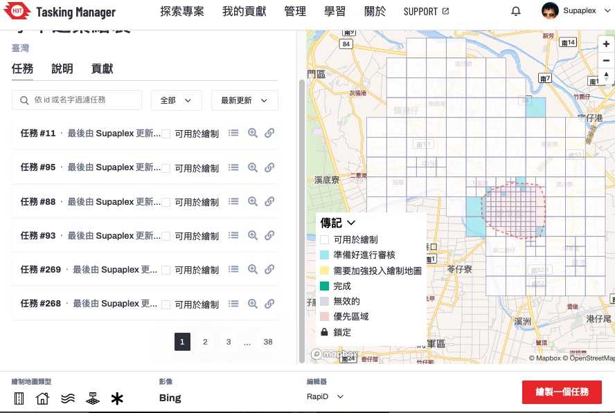
▲ Tasking Manager ê 專案,這改 boeh 繪製 ê 範圍-台南學甲區

這改成大圖客松 3/26 為止攏總 ū 107 个編輯變動,29 个 sī 工作人員 ê 編輯變動,3 个社群朋友 ê 編輯變動,22 位學生投入編輯總共 ū 75 个編輯變動,設定繪製 ê 目標建築,總共畫出 369 棟。

學生家己動手了後,投入 ê 狀況猶袂䆀,頭起先紹介𪜶 OpenStreetMap ê 基礎智識,閣來予𪜶知影資料 boeh 按怎產生–ê,落尾家己動手來做。毋過整體時間干焦一个半點鐘,其實時間無夠用,除非抵著比較庄腳 ê 任務,正常來講可能一塊當中 ê 建築攏畫袂完。

這改邀請方 sī 成大測量系,佮老師話仙時,𪜶定定 teh 運用 OpenStreetMap 資料,老師和社群部分 sī 熟似早年 ê OpenStreetMap 台灣社群走跳 ê Dongpo,因此 OpenStreetMap 相關 ê 智識 sī tuì Dongpo 來–ê,嘛是真合理 ê 代誌,因為 Dongpo 嘛是空間資訊學科背景 ê 人。

台南成大 
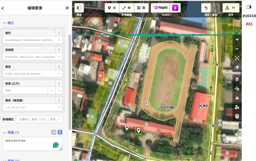
▲ 台南成大 tī OpenStreetMap 頂懸畫甲真詳細

進前已經由社群資深成員 kā 傷大 ê 土地利用拆解處理,這是進前台南土地利用 ê 歷史遺留問題。社群朋友建議會當教關掉特定圖徵。我 ê 回應 sī 若是 boeh 畫台南市東區抑是中南區 ē 關掉,毋過學甲 ê 資料量應該 sī bô chōe,boeh 畫 ê時愛 kā 畫面變大,應該袂無細膩 kā 地址點位合併掉–ah。

進前討論工作坊 ài 做啥物 ê 時,有想著用 MapRoulette ê 任務,毋過解微型任務傷技術 kah 資料導向–ah,學生可能袂明白佇咧創啥,閣來 sī MapRoulette 網站傷無穩定–ah,頂擺 OSMF Board meeting Martijn van Exel 還有上去報告,拍算請求 OSMF 資源協助。到時陣若是真正用 MapRoulette 有可能拄著網站掛–ah。

紲落來任務 ê 拍算,抑是 boeh 聽候台灣社群 ê 逐家有閒 sî 來畫畫,因為工作坊參與者閣來編輯 ê 比率無懸。學生 ū 傷濟好耍 ê 代誌會當做。目前 tī OpenStreetMap Taiwan 內 ū 四个畫地圖專案,閣看覓情況多開 HOT Tasking Manager 專案來處理台灣特定地方 ê 資料,敬請期待。

Location: 大學里, 東區, 臺南市, 701, 臺灣
Posted by Cyberjuan on 5 April 2024 in English. Last updated on 10 April 2024.

 It is with great excitement that we present to you the Organizing Committee of the SotM LATAM 2024 which will take place in Belem, Brazil, from December 6 to 8 of this year.

This volunteer committee has, among others, the functions that the SotM Working Group assumes in the global SotM, that is, mainly:

  • seeking a host location,
  • arranging sponsorship,
  • organising the detail of the conference,
  • promoting the conference, and
  • running the conference.

This committee is made up of those who, at the last AbreLatam 2023 in Montevideo, Uruguay, had the initial idea of holding the SotM Latam together with the FOSS4G 2024 that was announced at said event. Other map enthusiasts have been joining this initial group, contributing different visions and perspectives that we are sure will enrich SOTM LATAM 2024.

Member Representation Position Role
Raphael de Assis UMBRAOSM President Local committee
Roberto de Andrade UMBRAOSM Secretary Local committee
Vitor George Brazil Community Member IT
Anderson Toniazo Brazil Community Member Academic committee
Rodrigo Smarzaro Youthmappers UFV Member Local committee
Tatiana Pará OsGeo Brasil Member FOSS4G, Local committee
Selene Yang Geochicas Member Diversity, Equity, Inclusion
Juan Ángel Barajas Youthmappers LATAM Member Programming committee
Juan Arellano OSM LATAM Member Comunication

We will soon be announcing the formation of the other work committees: Local committee, IT/Communications committee, Programming committee and Academic committee.

Location: Mario Rivera, Yavari, Province of Mariscal Ramón Castilla, Loreto, Peru

Presentation of the Organizing Committee of SOTM LATAM 2024 in Brazil. Amazônia, Belém - Pará Brazil

It is with great excitement that we introduce you to the Organization Committee of SotM LATAM 2024 that will take place in Belén, Brazil, from December 6 to 8 of this year.

It is with great excitement that we introduce you to the Organization Committee of SotM LATAM 2024 that will take place in Belén, Brazil, from December 6 to 8 of this year.

This volunteer committee has, among others, the functions that the SotM Working Group assumes in the global SotM, that is, mainly:

Determine the location of the event, Coordinate sponsorships, Approve the event schedule, Promote the event Direct the event. This committee is made up of those who, at the last AbreLatam 2023 in Montevideo, Uruguay, had the initial idea of ​​holding the SotM Latam together with the FOSS4G 2024 that was announced at said event. Other enthusiasts have been joining this initial group, contributing different visions and perspectives that we are sure will enrich SOTM LATAM 2024.

Member Representation Position Function

Raphael de Assis UMBRAOSM President Local Committee

Roberto de Andrade UMBRAOSM Secretary Local Committee

Vitor George Community Brazil Member IT

Anderson Toniazo Community Brazil Member Academic Committee

Rodrigo Smarzaro Youthmappers UFV Member Local Committee

Tatiana Pará OsGeo Brazil FOSS4G Member, Local Committee

Selene Yang Geochicas Member Diversity, Equity, Inclusion

Juan Ángel Barajas Youthmappers LATAM Programming Committee Member

Juan Arellano OSM Peru Member Communication

We will soon be announcing the formation of the other work committees: Local Committee, IT/Communications Committee, Programming Committee and Academic Committee.

Organizing Committee of SotM Latam 2024 Belém - Pará - Brazil https://wiki.openstreetmap.org/wiki/ES:LatAm/Eventos/State_of_the_Map_Latam_2024 https://2024.osmlatam.org/

Contact: state@osmlatam.org

Location: Marco, Belém, Região Geográfica Imediata de Belém, Região Geográfica Intermediária de Belém, Pará, North Region, Brazil
Posted by Cyberjuan on 5 April 2024 in Spanish (Español). Last updated on 10 April 2024.

 Es con gran emoción que les presentamos al Comité de Organización del SotM LATAM 2024 que tendrá lugar en Belén, Brasil, del 6 al 8 de diciembre de este año.

Este comité de voluntarios tiene entre otras las funciones que en los SotM global asume el Grupo de Trabajo del SotM, es decir principalmente:

  • Determinar la sede del evento,
  • Coordinar los patrocinios,
  • Aprobar la programación del evento,
  • Promover el evento
  • Dirigir el evento.

Este comité está conformado por quienes en el pasado AbreLatam 2023 en Montevideo, Uruguay, tuvieron la idea inicial de realizar el SotM Latam junto al FOSS4G 2024 que fue anunciado en dicho evento. A este grupo inicial se han ido sumando otros entusiastas que vienen aportando distintas visiones y perspectivas que estamos seguros enriquecerán el SOTM LATAM 2024.

Miembro Representación Cargo Función
Raphael de Assis UMBRAOSM Presidente Comité local
Roberto de Andrade UMBRAOSM Secretario Comité local
Vitor George Comunidad Brasil Miembro TI
Anderson Toniazo Comunidad Brasil Miembro Comité académico
Rodrigo Smarzaro Youthmappers UFV Miembro Comité local
Tatiana Pará OsGeo Brasil Miembro FOSS4G, Comité Local
Selene Yang Geochicas Miembro Diversidad, Equidad, Inclusión
Juan Ángel Barajas Youthmappers LATAM Miembro Comité de Programación
Juan Arellano OSM LATAM Miembro Comunicación

Pronto estaremos anunciando la conformación de los demás comités de trabajo: Comité local, Comité de TI/Comunicaciones, Comité de Programación y Comité Académico.

Location: Tarapoto, San Martín, Perú
Posted by mayanaut on 5 April 2024 in English.

I’ve gotten most, if not all of the sidewalks mapped out within Avalon Borough. As I’ve worked eastward from Ben Avon, I’ve encountered a few other sidewalks mapped separately, many of which do not specifically note pedestrian crossings, so I plan to comb over those to see what I can make more consistent. There is a section of ORB/PA-65 where there are many crossings that are not tagged correctly. As this section is chock-full of turning vehicles, this seems rather dangerous, so I’m going to go through that area to map and tag things with pedestrian safety and accessibility in mind.

I have proceeded across the border into Bellevue, as well, with many of the above concerns in mind while tracing aerial photography.

Location: Avalon, Allegheny County, Pennsylvania, 15202, United States

Don’t worry, I won’t write a report every week!

So, the second week of capturing imagery with the GoPro Max granted by Meta is over. I’ve uploaded around 30,000 images since I started, but I’m not quite sure how many.

Here’s a little animation of my progress. It certainly helps me to stay motivated, if I can visualize my progress:

I still have only used it cycling and walking, but I had an ebike at my disposal on Easter Monday which was great for two reasons: The streets weren’t as busy because of the holiday, and I could obviously cover more ground. This was the only day so far that the camera battery ran out of energy before me. I might borrow it again to venture out further into the country.

I used the camera on the public bus as well, but obviously couldn’t use the 360 deg function, but instead just held it against the bus window from the inside. Not ideal, but I got some coverage of roads that had not been covered on Mapillary before at all. (Those do not appear in the animation, because I filtered for 360 imagery.)

It seems that Mapillary deals with the images a bit faster than during the first couple of days; usually they are fully processed after about two days now.

Interview on local radio

Yesterday, I gave a wee interview on one of our local radio stations about the project. I had hoped to inform the public about it that way, so that I don’t get as many looks of bewilderment, but I’m not sure that very many people listen to that radio station. If you’re interested, this is the link, and it starts around 47:59. It’s a bit of a pity I discovered that holy well, because it took valuable time off the interview which could have been used to address issues about privacy or whatever. However, I had suggested mentioning the holy well to him before the interview in the hope of finding out more about it, but then I found it out between that and the interview, but he liked the local history angle, I guess, so we stuck with it.

Panoramax

I’ve also started uploading some of the images to Panoramax, more as a test than anything, because we don’t have our own Irish instance of it yet. The uploading works like a charm, only it doesn’t show a map in the background: Panoramax screenshot

There’s a storm warning in place until tomorrow evening, so I don’t know if I will be able to keep up my streak, especially since I have to cycle further to even start capturing now.

Posted by spwoodcock on 4 April 2024 in English. Last updated on 13 April 2024.

ODK

For those that don’t know, ODK is an incredible suite of tools for field data collection.

The Field Mapping Tasking Manager(FMTM) leverages two of their tools to coordinate field tagging of map data:

  • ODK Central as the centralised server to store survey data.
  • ODK Collect as the mobile app for survey-based data collection on mobile phones (working very nicely in offline contexts too).

Entities

  • ODK Entities were introduced to Central in September 2023, in order to more easily track the same feature over time.
  • As a result, we have a nice way to store a feature, with geometry and properties, in ODK Central.
    • This could quite easily map to the OSM ID, feature geometry, and feature tags.
  • The geometry can then be selected in ODK Collect survey questions.

select-from-map-polygon

How To Use Entities

Create an Entity List

Within ODK Central, a collection of Entities is called an Entity List (or dataset via the API).

Currently the only way to define an Entity List is to submit a XLSForm with an ‘entities’ tab defining the entity_id field:

entities-tab

And a ‘survey’ tab defining additional properties/field for the Entities:

entities-survey-tab

Example generic Entity form

  • This will change in the future, with the possibility to create an Entity List / dataset via the Central API.

Populate Entities

Once the Entity List exists, you must populate the data:

Option 1: via the API. Manually uploading the Entity details.

Option 2: via CSV attachment. Entities can be uploaded as a CSV attachment to a form (in theory, although I have yet to make this work!).

Option 3: created automatically on submission by specifying a ‘geopoint’ or ‘geoshape’ field in your form (and collecting the location in the field).

Changes to FMTM

Until now, FMTM was frankly abusing ODK Central and had a structure like this:

FMTM Project 🔗 ODK Project

FMTM Task Area 🔗 ODK XForm (the survey)

FMTM Geometry 🔗 ODK XForm Attachments

This resulted in potentially hundreds of ODK XForms per project, which is not an ideal usage.

With Entities, the new mapping for FMTM is:

FMTM Project 🔗 ODK Project, ODK Entity List (Dataset), ODK XForm

FMTM Task Area 🔗 Group of ODK Entities (via task_id property)

FMTM Geometry 🔗 ODK Entity

This is a much more logical 1:1 mapping of the lowest level unit we are interested in: OSM features.

A World of Possibilities

  • Now Entities exist, it is possible to update Entity fields, as they are mapped in the field.
  • For example, after tags have been added to an OSM feature in FMTM and mapping is complete, a ‘STATUS’ field could be updated for the Entity as ‘complete’. This would inform other users of ODK Collect that this building has already been mapped.
  • Even more intuitively, the feature could be ‘soft deleted’ after mapping, so it so the geometry disappears entirely from another users phone. Or the Entity label could be updated with a big ✅.
  • There is a whole section on updating Entities from forms in the ODK documentation.

So Where Does OpenStreetMap Come In?

  • The goal of FMTM is to add useful field-verified metadata (tags) to features on a map.
  • For example, we have the outline of a school, but wouldn’t it be great to know: how many stories it is, what the walls and roof are made from, how many people are typically inside the building during the day?
  • FMTM mostly uses OSM data for import and updating these tags (it is also possible to use custom data that does not exist in OSM (yet!).
  • ODK Entities are essentially a representation of these OpenStreetMap features, that can be updated from detailed ODK surveys done in the field.
Location: Kalgodin, Ouagadougou, Kadiogo, Centre, Burkina Faso

Най-сетне дойде и времето да започна да картографирам района на любимото си село - Костенковци. Добавих почти всички сгради, за да мога като си отида лятото със StreetComplete да добавя повече подробности.

Добавих и паметника, който е там. Само остана да разбера как да добавя координатите към снимката му, за да излиза правилно в някои приложения.

Location: Костенковци, Лесичарка, Габрово, 5343, България
Posted by Marcelo Soares Souza on 3 April 2024 in English. Last updated on 18 April 2024.

We made the Agroecology Map data available in GeoJSON format so that you can use it in your analyses.

You can now export all data and use it under the Creative Commons 4.0 (BY-NC-SA 4.0) license.

See how easy it is to use the Agroecology Map data in the QGIS tool

https://youtu.be/w418y-eivmY?si=9cB-D9x7bf-zXhza

Find out more about the Agroecology Map at https://agroecologymap.org

Location: SQN 109, Asa Norte, Brasília, Plano Piloto, Região Geográfica Imediata do Distrito Federal, Região Integrada de Desenvolvimento do Distrito Federal e Entorno, Região Geográfica Intermediária do Distrito Federal, Federal District, Central-West Region, 70752-510, Brazil

I look forward to contributing to the map and will be donating money to the project too. Mostly, I will map things in the Rio Grande Valley of Texas. But I do travel quite a bit and would look forward to identifying things I find out on the road. My first contribution to the maps was to map Sandpipers Nudist Resort & RV Park. It’s a place that I call my winter home in Texas.

Posted by Supaplex on 3 April 2024 in English. Last updated on 4 April 2024.

We must thank TomTom Taiwan Office for arranging a workshop through their colleague’s connection with the Department of Survay, NCKU. The OpenStreetMap Taiwan Community has applied for the HOT Tasking Manager’s admin role for creating its local project that suits local needs. It is quite a good fit for the NCKU Workshop: using Tasking Manager for local mapping projects and mapping local stuff.

Tasking Manager ▲ Tasking Manager project page. This project’s main goal is to map Xiejie District, Tainan City.

There are a total of 107 changesets, 29 from our staff, and 3 from community members for the NCKU workshop. The number of participants from NCKU is 22 students with a total of 75 changesets. During the whole workshop, there are 369 buildings mapped.

When the students start doing the mapping, they are quite concentrated on the project. The lecturer first tells them the basic knowledge of OpenStreetMap, then the mapping process, and then finally lets the students begin mapping buildings. Due to the time slot limitation of only 1.5 hours, it is not enough time to map even a single task unless the mapper chooses a very rural area.

The host organization for the workshop is the Survey Department, NCKU. When chatting with the professor, the professor mentioned that they frequently use OpenStreetMap during research. The professor knows the early OpenStreetMap Taiwan community Dongpo, and his knowledge of OpenStreetMap comes from Dongpo. It is quite reasonable due to Dongpo’s background in geographic science.

NCKU in Tainan ▲ National Cheng Kung University is located in Tainan, which is quite well-mapped on OpenStreetMap

We have someone look at the huge land use issue which is a long long time ago import stuff, slicing the land use to a much smaller, manageable size. The other feedback from the community that I received, suggested closing certain map features. I think if we are mapping the old Tainan City, it is obvious that we should close nodes or POIs to make the whole loading map feature size smaller. But we are mapping Xiejia District, which is not in the city center, so the total data size and the possibility of mis-combined something is also small.

When we prepared for the NCKU workshop, we thought about the MapRoulette Challenge. But MapRoulette website is unstable and the micro-task is too technical and data-driven, which might confuse students. They might know the process but have no idea why they are doing it. At the last OSMF Board meeting, one of the members invited MapRoulette website author Martijn van Exel to report during the board meeting, asking for assistance from OSMF for the MapRoulette website. If we use MapRoulette, we might run into downtime.

After 3/25, we must ask Taiwan’s community for a favor and continue mapping the project. It should be expected that students have a low retention rate. School life is fun and they have so much stuff to do. The Taiwan community will open other tasks for mappers to map specific Taiwan areas.

We also have feedback for HOT. They are quite good for training the Tasking Manager admin role. After you join the HOT Slack Workplace, you can ask questions in real-time and soon get a response. For the embedded editors in HOT Tasking Manager, both the iD and Rapid localization are not set correctly to zh-tw, but to zh. The community in Taiwan has already translated many of the terms on the Transifex translation platform from English to Taiwanese Mandarin. We explained to the student that we already fully translated the UI interface, but the language detection and setting were wrong.

In the long term, the community is looking forward to promoting in schools, whether we are in universities or high schools, there is a one-time or multi-time workshop event. We want to show the real way of mapping - in a community way. Just like the workshop in NCKU, using HOT Tasking Manager to split a big area into smaller tasks for mapping. Right now we only can observe the history pages to know if there might be a school workshop mapping in the surrounding area. And normally school teachers are not familiar with OpenStreetMap, and the student’s edit situations vary. If there is a community member who can guide, will make the whole mapping event much smoother and avoid trouble edits.

Location: Daxue Village, Eastern District, Tainan, 701, Taiwan

Who did it screenshot at Bajo Sinú área

I want to share my personal use of one tool I’m learning at #UNMappers Validation training guided by SeverinGeo

At Colombia OSM community there was some discussion a while back about best practices for users tracking changes in specific zones.

I know that you are tracking the areas you map. I have been doing that work with a particular area in which we have an organized mapping project, the Bajo Sinu River basin, Cordoba, Colombia.

I have been using a simple script from FeedForAll called rss2html, that helps me to publish RSS feeds in a .php by myself. I use it as source to make Humanitarian and Human Rights simple News dashboards for people not too related to tech stuff, but in need of information, working and living in field.

For example, with Rss2Feed I use a News feed for Arauca region in Colombia, one of the most affected areas by Human Rights violation and breaches of International Humanitarian Law events.

Following this practice I can monitor via web the report generated by WHO DID IT about the changes in the Bajo Sinú. You can see it HERE

This is a side tool because the RSS can be followed with a RSS news reader app directly from the link generated by Who did it.

Here is the info in case you are interested in going deeper:

Alert Note: Don’t download the link generated by Who did it. If you do this, your browser will start opening and opening tabs until you close your browser or exhaust your PC. The RSS file downloaded starts an endless loop. It happened to me and the reason behind this story.

screenshot from Whodid it at RSS link

Location: Lorica, Bajo Sínú, Córdoba, RAP Caribe, 231020, Colombia

¡Después de varios años sin realizar un State of the Map LATAM, este año tendremos nuevamente un encuentro de la comunidad OpenStreetMap latinoamericana de forma presencial en Brasil! Los días 7 y 8 de diciembre se llevará a cabo el SotM 2024 en la ciudad de Belén, una ciudad brasileña en la desembocadura del río Amazonas.

Como podrán suponer, este evento necesita contar con un elemento gráfico reconocible que represente tanto al espíritu de la ciudad de Belén como a la comunidad latinoamericana. El logo sirve además para definir el diseño y colores del sitio web oficial. También se usará para marketing y artículos promocionales del SotM (camisetas, calcomanías, etc.).

Así pues ¡necesitamos la ayuda de los creativos en diseño de la comunidad para contar con el nuevo logo del SotM 2024! Todos pueden participar en esta convocatoria, ¡Desde experimentados profesionales hasta novatos y entusiastas del diseño gráfico!

Bases del concurso

El diseño del logo debe:

  • ser una obra de arte original;
  • referenciar a OpenStreetMap (OSM) y al estado del mapa (SotM);
  • representar al espíritu de la ciudad de Belén y a la comunidad latinoamericana;
  • ser fácilmente reconocible;
  • ser de Licencia abierta: CC BY SA o relacionada;
  • enviarse antes del domingo 21 de abril de 2024 a las 23:59 UTC-5

Cómo participar

Envía tu propuesta de logotipo por correo electrónico con el asunto “Propuesta Logo SotM 2024” a state@osmlatam.org con CC umbraosm@gmail.com, adjuntando el archivo de diseño en formato PNG y en formato de archivo escalable (como PDF o SVG).

Selección del ganador

Las obras de arte enviadas serán revisadas por el Comité de Organización del SotM, y el logo ganador se decidirá mediante votación.

El logo oficial se anunciará a principios de mayo.

¿Buscas algo de inspiración? Echa un vistazo a los logos de los anteriores SotM LATAM: https://wiki.openstreetmap.org/wiki/ES:LatAm/SOTM_Latam o a los SotM globales: https://wiki.openstreetmap.org/wiki/State_of_the_Map.

Si tienes alguna pregunta sobre la convocatoria, no dudes en ponerte en contacto con state@osmlatam.org.

El Comité de Organización del SOTM

La conferencia State of the Map es la conferencia internacional anual de OpenStreetMap, organizada por la Fundación OpenStreetMap. La Fundación OpenStreetMap es una organización sin fines de lucro, formada en el Reino Unido para apoyar el Proyecto OpenStreetMap. Se dedica a fomentar el crecimiento, el desarrollo y la distribución de datos geoespaciales gratuitos para que cualquiera pueda usarlos y compartirlos. La Fundación OpenStreetMap posee y mantiene la infraestructura del proyecto OpenStreetMap. El Comité Organizador del State of the Map es uno de nuestros Grupos de Trabajo voluntarios.

OpenStreetMap se fundó en 2004 y es un proyecto internacional para crear un mapa libre del mundo. Para hacerlo, nosotros, miles de voluntarios, recopilamos datos sobre carreteras, ferrocarriles, ríos, bosques, edificios y mucho más en todo el mundo. Todos pueden descargar nuestros datos de mapas de forma gratuita y utilizarlos para cualquier propósito, incluido el uso comercial. Es posible producir tus propios mapas que resalten ciertas características, calcular rutas, etc. OpenStreetMap se usa cada vez más cuando se necesitan mapas que se pueden actualizar muy rápida o fácilmente.

Location: 1 de Octubre, Lima, Lima Metropolitana, Lima, 15101, Perú